Warmer Weather and More Smoke Ahead

Warmer Weather and More Smoke Ahead


Seattle PanoCam images at 6:10 and 6:30 AM Monday morning looking northwest from the Space Needle --the eastward-moving smoke is obvious

Our cool respite with little wildfire smoke is over.

High pressure is building over the inland western U.S., resulting in increasing offshore and southerly flow that will bring more smoke into western Washington.

Currently, there are a number of small and moderate-size fires burning over the Northwest (see map), plus plenty in California (see image).

High pressure starts building along the West Coast (see upper level map for Tuesday morning).

At the surface, high pressure will be building inland, resulting in easterly flow and the development of a thermal trough (low pressure) extending and amplifying from CA to WA (see surface map at 2 AM Wed).

These changes will produce increasing flow from the south and east that will move smoke our way.  The smoke map from the NOAA HRRR smoke system for 5 PM (below) shows eastern WA smoke pushing into the eastern side of the lowlands....which was very obvious if you looked eastward towards the Cascades today.
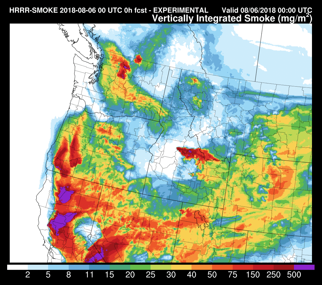


The situation worsens by 5 PM Monday (see below) as massive amounts of California and SW Oregon smoke pushes northward.  Skies will get hazy and the sun weakened.


Finally, by 11 AM on Tuesday, relatively dense smoke from CA and southern Oregon will extend over our region.   Our air quality at the surface will depend critically on how much of this smoke mixes down to the surface.


There was a large amount of lightning yesterday associated with thunderstorms over the Cascades (see below)..... I am worried that some of these strikes might have started new fires.

3D Smoke

Satellite imagery shows smoke moving in over head (see below) and our sunsets/sunrises confirm it.


But yet the air quality is very good near the surface, something shown by the measurements of the Puget Sound Clean Air Agency (see below), with the near sea level sites being green (good air quality).   But note that Rainier and a few sites near the Cascade slopes are yellow (moderate air quality)


In contrast, head down to California, and smoke has engulfed the lower atmosphere, as beautifully illustrated by the picture of the region around Mt. Shasta sent to me by Kean Stump.


The NOAA HRRR-smoke forecast predicted this situation. The forecast for total smoke in the column at 5 PM today was scary.


But the smoke forecast at the surface at the same time was pretty benign for the Puget Sound lowlands (see below).  Plenty of smoke in eastern Washington and California at low levels, though


In contrast, there was much more smoke predicted at 6000 ft.


The reason for this pattern?  There was northerly (from the north) winds at low levels over western WA, that brought in clean air from the north and west, while southerly flow aloft moved the California and Oregon smoke northward above us aloft---high enough that it wasn't mixed to the surface.

We can show this by creating backward trajectories of the air at various levels above Seattle--telling us where the air came from over us. This plot (from the wonderful NOAA HYSPLIT model) shows the trajectories ending over Seattle at three heights (100 meters--red, 1500 meters--blue, and 2500 m--green) at 5 AM this morning. The 100m trajectory moved through the Strait of Juan de Fuca...nice clean ocean air.  But the higher trajectories cam from the south (blue and green)--in the middle of smoke land.


We can also do forward trajectories that describe where air will go...here are the forward trajectories from a location over northern California, starting at the same three elevations.  The low-level smoky air (red) moves northward, while rising substantially (to about 4000 meters).  Less rising for air starting at 1500 meters.


The bottom line:  the low-level northerly flow is protecting us today, allowing the smoke to stay aloft.    

Whether we get smoke to the surface is critically dependent on how low the upper smoke layer drops.....if it gets below 5000 ft then vertical mixing can bring it down to the surface during the day.

The situation should be similar on Wednesday.....

New Podcast: Why is November the Stormiest Period of the Year and the Forecast for Next Week

  Believe it or Not! On average, we are now past the worst weather of the winter!  Shocking but true.  And in the second segment of my podca...