But yet the air quality is very good near the surface, something shown by the measurements of the Puget Sound Clean Air Agency (see below), with the near sea level sites being green (good air quality). But note that Rainier and a few sites near the Cascade slopes are yellow (moderate air quality)
In contrast, head down to California, and smoke has engulfed the lower atmosphere, as beautifully illustrated by the picture of the region around Mt. Shasta sent to me by Kean Stump.
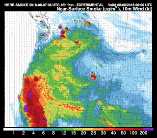
But the smoke forecast at the surface at the same time was pretty benign for the Puget Sound lowlands (see below). Plenty of smoke in eastern Washington and California at low levels, though
In contrast, there was much more smoke predicted at 6000 ft.
The reason for this pattern? There was northerly (from the north) winds at low levels over western WA, that brought in clean air from the north and west, while southerly flow aloft moved the California and Oregon smoke northward above us aloft---high enough that it wasn't mixed to the surface.
We can show this by creating backward trajectories of the air at various levels above Seattle--telling us where the air came from over us. This plot (from the wonderful NOAA HYSPLIT model) shows the trajectories ending over Seattle at three heights (100 meters--red, 1500 meters--blue, and 2500 m--green) at 5 AM this morning. The 100m trajectory moved through the Strait of Juan de Fuca...nice clean ocean air. But the higher trajectories cam from the south (blue and green)--in the middle of smoke land.
We can also do forward trajectories that describe where air will go...here are the forward trajectories from a location over northern California, starting at the same three elevations. The low-level smoky air (red) moves northward, while rising substantially (to about 4000 meters). Less rising for air starting at 1500 meters.
The bottom line: the low-level northerly flow is protecting us today, allowing the smoke to stay aloft.
Whether we get smoke to the surface is critically dependent on how low the upper smoke layer drops.....if it gets below 5000 ft then vertical mixing can bring it down to the surface during the day.
The situation should be similar on Wednesday.....


No comments:
Post a Comment